BVLOS Revolution: Autonomous Drone Operations Transform Construction Monitoring
How FAA Part 108 Regulations Enable AI-Powered Aerial Surveying, Real-Time LiDAR Mapping, and Digital Twin Integration for Construction Sites
Date Published
June 10, 2025 | 6-min read
The construction industry stands at the edge of a regulatory cliff – and for once, that's excellent news. The FAA's impending Part 108 rule for Beyond Visual Line of Sight (BVLOS) drone operations will fundamentally transform how construction sites are monitored, measured, and managed. For construction professionals in Florida and beyond, this shift from restrictive waivers to standardized autonomous operations represents the most significant advancement in aerial surveying since drones first took to construction site skies.
The current state of construction aerial surveying
Today's construction drone operations face a fundamental limitation: visual line of sight requirements. Every drone flight requires an operator maintaining constant visual contact, effectively tethering advanced technology to human eyesight limitations. This restriction transforms what should be efficient aerial data collection into a resource-intensive process requiring multiple operators for large projects.
Florida Aerial Survey Technologies has optimized current workflows to deliver 3-5 day turnaround times even under these constraints, processing up to 300 acres of construction site data. But imagine what becomes possible when those visual tethers are cut. Current construction projects requiring 2-3 weeks of traditional surveying already compress to 1-3 hours of flight time. With BVLOS operations, that efficiency multiplies exponentially.
The numbers tell a compelling story. Construction firms currently achieve 5-20X cost savings per project using restricted drone operations. BVLOS promises to push those multipliers even higher, particularly for infrastructure projects spanning multiple miles – think highway construction, pipeline monitoring, or large-scale residential developments stretching across Florida's expanding communities.
Understanding BVLOS impact on construction workflows
The shift from visual line of sight to autonomous operations isn't merely an incremental improvement – it's a fundamental reimagining of construction site data collection. BVLOS enables continuous, automated monitoring without the need for on-site operators, transforming reactive site management into proactive project intelligence.
Consider a typical highway construction project stretching 10 miles through varied terrain. Current regulations require multiple operator teams, coordinated handoffs, and complex logistics to maintain visual contact throughout the corridor. Each setup, teardown, and transition adds hours to the survey process. BVLOS operations eliminate these inefficiencies entirely, allowing a single autonomous drone to capture the entire project alignment in one continuous flight.
The technology extends beyond simple efficiency gains. Real-time data processing capabilities mean construction managers receive actionable intelligence while earth is still being moved, not days later when corrections become exponentially more expensive. For Florida's construction industry, where weather windows and seasonal considerations drive project schedules, this immediacy transforms project management from reactive to predictive.
LiDAR and photogrammetry convergence in autonomous operations
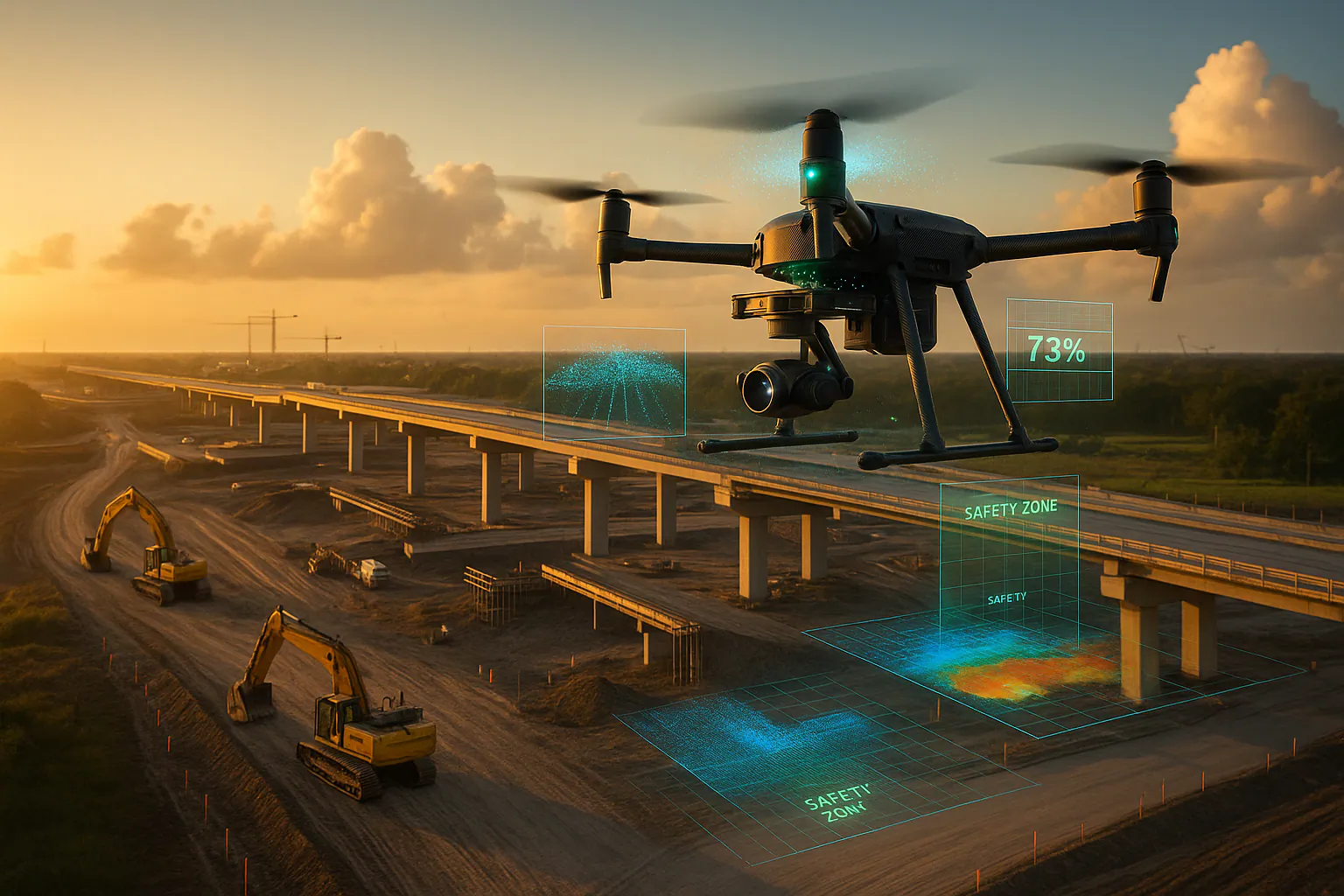
The marriage of BVLOS operations with advanced sensor technology creates unprecedented construction monitoring capabilities. Modern drone-mounted LiDAR systems weighing under 1kg deliver survey-grade accuracy while maintaining flight times suitable for extended autonomous missions. This miniaturization, combined with multi-sensor fusion, enables single flights to capture comprehensive site data previously requiring multiple specialized surveys.
Centimeter-level accuracy becomes standard, not exceptional, when RTK/PPK GPS integration combines with solid-state LiDAR and high-resolution photogrammetry. For construction applications, this precision translates directly to reduced rework, accurate volumetric calculations, and precise progress tracking. Earthwork contractors can verify cut-and-fill operations daily rather than monthly, catching discrepancies before they compound into costly overruns.
The integration capabilities extend into existing construction technology ecosystems. Point cloud data flows seamlessly into Building Information Modeling (BIM) platforms, enabling real-time comparison between as-designed and as-built conditions. This integration transforms static 3D models into living digital twins that reflect actual site conditions, not theoretical projections.
Digital twins and AI-powered construction intelligence
The convergence of BVLOS operations, advanced sensors, and artificial intelligence creates a new paradigm: intelligent construction monitoring. AI-powered drones don't just collect data – they interpret it, identifying safety hazards, tracking equipment utilization, and predicting potential delays before they impact schedules.
Machine learning algorithms trained on thousands of construction sites can identify patterns invisible to human observers. Equipment idle time, material stockpile depletion rates, and workforce distribution patterns emerge from the data, enabling project managers to optimize resources proactively. Safety improvements of 30% aren't theoretical – they're documented results from sites employing AI-driven aerial monitoring.
Digital twin technology amplifies these benefits exponentially. Real-time site mirroring through continuous drone data updates creates a virtual construction site accessible from anywhere. Stakeholders can walk through current conditions, analyze progress, and identify issues without setting foot on site. For Florida's construction industry, where projects span from the Panhandle to the Keys, this virtual presence revolutionizes project oversight.
Preparing for the BVLOS transformation
While the FAA's Part 108 rule won't be finalized until 2026, forward-thinking construction companies should begin preparing now. The competitive advantages for early adopters will be substantial, particularly in Florida's rapidly growing construction market.
Technology infrastructure forms the foundation. Companies need robust data processing capabilities to handle the increased volume of autonomous operations. Cloud-based platforms that can process, store, and analyze terabytes of point cloud data become essential infrastructure, not optional upgrades. Florida Aerial Survey Technologies has invested in custom-built, specialized computing systems that process even 300-acre sites with 3-5 day turnaround – infrastructure that becomes even more critical as data volumes increase.
Training and certification represent another critical preparation step. While BVLOS operations reduce the need for visual observers, they increase the importance of mission planning, data management, and safety protocol expertise. Construction companies should invest in developing internal drone program management capabilities now, building the institutional knowledge required for successful autonomous operations.
Partnership strategies matter more than ever. As construction technology becomes increasingly sophisticated, collaboration between construction firms and specialized aerial survey providers like Florida Aerial Survey Technologies creates synergies impossible to achieve independently. These partnerships combine construction expertise with aerial survey specialization, delivering outcomes neither party could accomplish alone.
The bottom line for construction professionals
The BVLOS revolution isn't coming – it's here, waiting only for regulatory approval to unlock its full potential. Construction professionals who prepare now will find themselves with significant competitive advantages: dramatically reduced survey costs, accelerated project timelines, enhanced safety outcomes, and data-driven decision-making capabilities that transform project management.
For Florida's construction industry, where growth shows no signs of slowing and project complexity continues to increase, BVLOS operations represent more than technological evolution – they're a business imperative. The question isn't whether to adopt autonomous aerial monitoring, but how quickly you can position your organization to capitalize on this transformation.
The construction sites of 2025 and beyond will be continuously monitored, intelligently analyzed, and proactively managed through autonomous aerial systems. Florida Aerial Survey Technologies stands ready to help construction professionals navigate this transformation, bringing decades of surveying expertise combined with cutting-edge aerial technology to every project. The future of construction monitoring has arrived – and it's flying autonomously overhead.
Related Construction Posts

June 9, 2025
Florida's Drone Dilemma: Security vs. Hurricane Response
Florida's emergency management agencies face a critical crossroads. With the American Security Drone Act's full implemen...

May 12, 2025
Precision agriculture 2025: Drones and AI transform crop yields
In 2025, agriculture is undergoing a transformative shift powered by drone technology and artificial intelligence. No lo...

May 9, 2025
How drones accelerate permitting for land development
Drone mapping is helping developers streamline due diligence, environmental studies, and planning approvals. With faster...