Read more about the article Topography: Everything you need to know about topography.
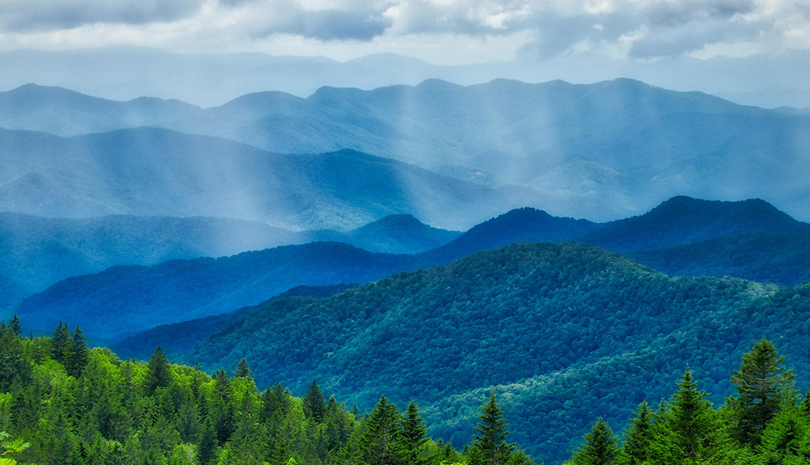
Mountains are considered topography

Topography: Everything you need to know about topography.

A definitive guide to topography Got questions about topography? We have answers. Topography is the representation of earth's surface and artificial made modifications on a map. It is used to…

Continue ReadingTopography: Everything you need to know about topography.
Read more about the article What is Inventory Turnover Ratio?
Florida Aerial Survey Technologies provides inventory turnover ratio surveys for companies looking to measure the turnover of their inventory.

What is Inventory Turnover Ratio?

What is Inventory Turnover Ratio? A measurement of efficiency that provides solid data on how well a company is managing and moving inventory. Inventory turnover ratio is one of the…

Continue ReadingWhat is Inventory Turnover Ratio?

Two Reasons Drones Improve Aggregate Volume Calculations

Improving Aggregate Volume Calculations Using Drone Surveying How our cutting edge technology has changed the aggregate volume measurement game. As any one of our clients can tell you, having accurate…

Continue ReadingTwo Reasons Drones Improve Aggregate Volume Calculations
Read more about the article 3 Differences between Drone Mapping & Traditional Surveying
This photo shows a highly accurate 3d model of a commercial development. This model was made using drone mapping methods.

3 Differences between Drone Mapping & Traditional Surveying

Drone Mapping vs Traditional Mapping. How our cutting edge technology has changed the site design game. The advancements in drone technology and mapping software are revolutionizing the survey industry. The…

Continue Reading3 Differences between Drone Mapping & Traditional Surveying
Read more about the article Innovative Drone Surveys for Beach and Coastal Projects
A photo from the survey of Barefoot Beach in Naples, Florida

Innovative Drone Surveys for Beach and Coastal Projects

Using Drones to Survey Beaches and Coastal Projects Part One: Municipalities, Counties, and Governments. On coastal projects such as beach re-nourishment, jetty construction and repair, and wildlife monitoring aerial surveying…

Continue ReadingInnovative Drone Surveys for Beach and Coastal Projects
Read more about the article How New Aerial Survey Technology Helps Coastal Engineering Firms
Our aerial surveys greatly increase the accuracy and completeness of the data provided to engineering firms.

How New Aerial Survey Technology Helps Coastal Engineering Firms

Three ways Aerial Surveys help Coastal Engineers. F.A.S.T. owner Andrew Kobza makes an... interesting analogy. Coastal projects are extremely complex works of engineering. Blending nature and humanity, a successful coastal…

Continue ReadingHow New Aerial Survey Technology Helps Coastal Engineering Firms
Read more about the article A Brief Introduction to Aerial Surveying and Drone Mapping
DCIM100MEDIADJI_0037.JPG

A Brief Introduction to Aerial Surveying and Drone Mapping

A brief introduction to our aerial surveying Florida Aerial Survey Technologies has many methods for collecting aerial survey data. Our proprietary methods and processes have been designed to ensure control…

Continue ReadingA Brief Introduction to Aerial Surveying and Drone Mapping
Read more about the article Infographic: 3 Brilliant Differences Between Drone Surveying &Traditional Surveying
This infographic lays out the different ways Florida Aerial Survey Technologies products stack up to our competition.

Infographic: 3 Brilliant Differences Between Drone Surveying &Traditional Surveying

Drone Surveying for Construction and Engineering Transforming data in construction - Now. At Florida Aerial Survey Technologies (F.A.S.T.) we use cutting edge, proven survey and modeling techniques as well as custom…

Continue ReadingInfographic: 3 Brilliant Differences Between Drone Surveying &Traditional Surveying