Drone stockpile surveys streamline Pensacola asphalt operations
FAST enabled recurring volume tracking and airspace compliance near restricted zones
Date Published
May 9, 2025 | 2-min read
Recurring drone surveys at the Pensacola Asphalt Plant ensure precise material inventory and airspace compliance. FAST’s data portal and expertise support efficient operations in a highly regulated flight zone.
Introduction
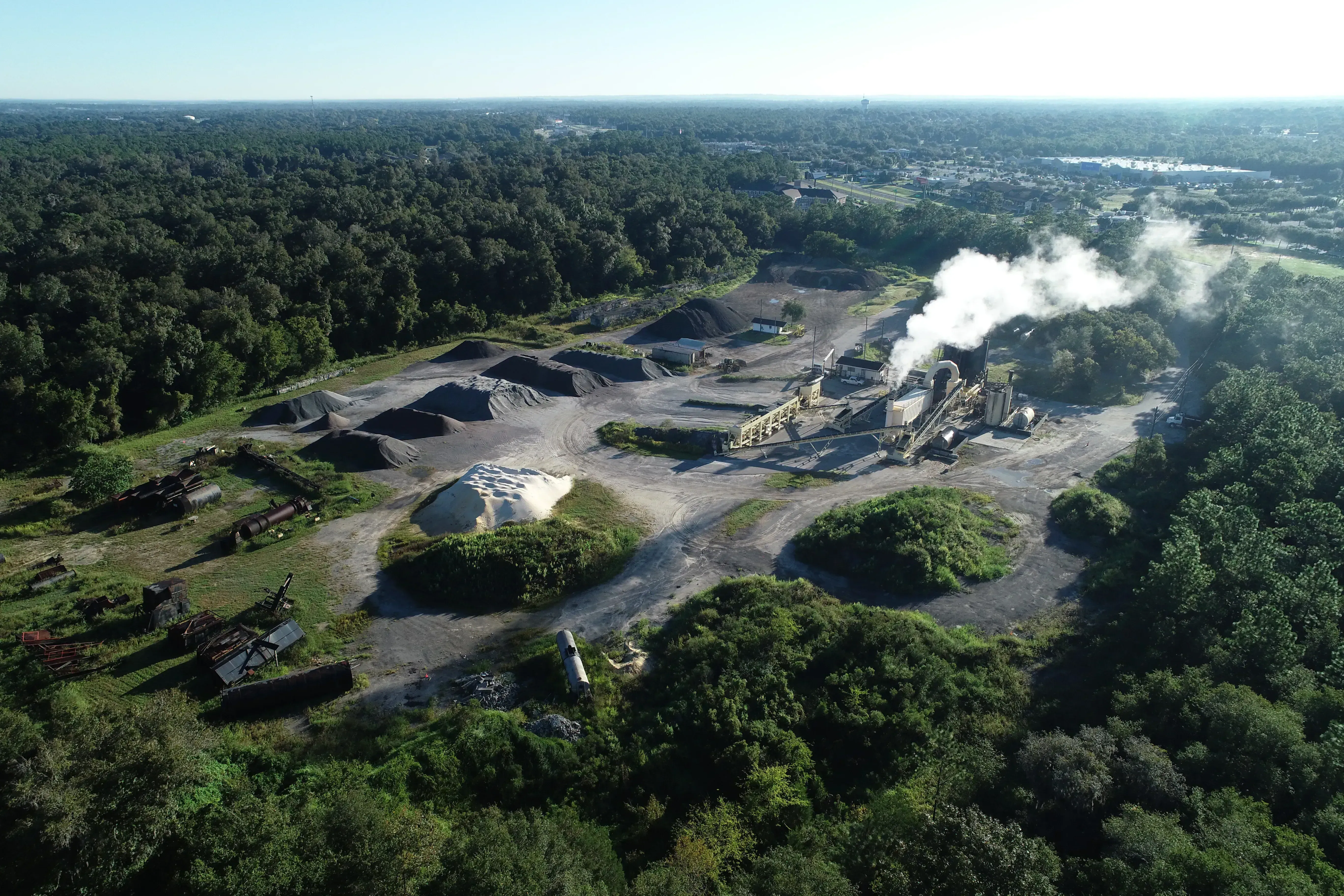
At the Pensacola Asphalt Plant, managing stockpile volumes near restricted airspace poses daily challenges. Situated near an international airport and Air Force base, the site demands precise aerial operations. FAST tackled this with advanced drone surveying, offering inventory precision and full regulatory compliance. Our unified data portal enhances accessibility, empowering site managers with fast, reliable insights. How do you ensure high-accuracy volume data without disrupting safety or compliance near controlled airspace?
Problem / Backgroun
Managing material stockpiles near restricted airspace involves significant operational risk and complexity. Within this highly sensitive airspace, traditional survey methods are cumbersome and prone to delays. Compliance with FAA regulations and coordination with local airspace authorities is essential. Meanwhile, the plant’s operations require accurate, recurring inventory data to manage aggregate flow, meet production schedules, and prevent costly overages or shortages. This dual challenge—regulatory and operational—called for a partner with both technical and procedural expertise.
Recurring drone surveys with full airspace compliance
FAST deployed a combination of RTK-enabled drones and certified FAA Part 107 pilots to execute precise stockpile surveys on a recurring schedule. With our expertise in controlled airspace coordination, we handled all waiver processes and flight permissions, minimizing disruption to the plant’s operations.
The team ensured quick turnarounds by combining advanced data processing with streamlined upload-to-portal integration, allowing site managers to view results within hours after flights. All data—including volume reports and orthomosaics—was accessible through our secure web-based viewer.
- Precision drone surveys ensure accurate stockpile volume tracking
- Seamless FAA coordination avoids workflow disruptions
- Unified portal simplifies access to survey history and insight
Results / Benefits
Thanks to FAST’s recurring drone services, the Pensacola Asphalt Plant improved both efficiency and compliance. Material miscalculations were reduced, and the reliable tracking enabled better resource planning and cost control. Regulatory delays became a non-issue due to proactive airspace management.
This end-to-end approach has saved the client time and money while streamlining operational decisions via immediate access to historical data and trends.
- Time reduced from **manual coordination days** to **automated 24h turnaround**
- Accuracy improved from **±10% estimates** to **centimeter-grade validation**
- Cost savings of **15–20 %**
Conclusion
Recurring drone surveys from FAST are transforming how material plants manage stockpile data in complex airspaces. With precise volume measurements and seamless regulatory handling, the Pensacola Asphalt Plant enjoys reliable insights and smoother operations.
Related Industries Posts

May 12, 2025
Autonomous drones cut costs in infrastructure inspections
In 2025, infrastructure inspection is being redefined by a new generation of autonomous drones. These systems – often pa...

May 9, 2025
Clewiston sugar plant relies on monthly drone surveys
Each month, FAST delivers precise stockpile data to the Clewiston sugar plant—supporting a multi-billion-dollar supply c...

May 9, 2025
Drone topographic mapping accelerates Myakka golf project
FAST performed a full 600-acre topographic survey for a golf course in Myakka, delivering net cut/fill analysis, contour...